| 1 |
工业和信息化部,公安部,自然资源部,等.工业和信息化部公安部自然资源部住房和城乡建设部交通运输部关于开展智能网联汽车“车路云一体化”应用试点工作的通知[Z]. 2024.
|
|
Ministry of Industry and Information Technology, Ministry of Public Security, Ministry of Natural Resources, et al. Notice of the ministry of industry and information technology, ministry of public security, ministry of natural resources, ministry of housing and urban-rural development, ministry of transportation on the pilot work of “vehicle-road-cloud integration” application of intelligent connected vehicles[Z]. 2024.
|
| 2 |
中国汽车工程学会.自主代客泊车系统总体技术要求:T/CSAE-156—2020[S/OL].[2024-04-25].
|
|
China Society of Automotive Engineers. General technical requirements of autonomated valet parking systems: T/CSAE-156—2020[S/OL].[ 2024-04-25].
|
| 3 |
HUANG G, HU Z Z, TAO Q W, et al. Improved intelligent vehicle self-localization with integration of sparse visual map and high speed pavement visual odometry[J]. Journal of Automobile Engineering, 2021,235(1):177-187.
|
| 4 |
HUANG Y W, ZHAO J Q, HE X D, et al. Vision-based semantic mapping and localization for autonomous indoor parking[C]. Proceedings of 2019 IEEE International Conference on Robotics and Automation(ICRA),2018:636-641.
|
| 5 |
安鑫,蔡伯根,上官伟.车路协同路侧感知融合方法的研究[J].测控技术,2022,41(2):1-12,35.
|
|
AN X, CAI B G, SHANGGUAN W. Vehicle road cooperative roadside perception fusion method[J]. Measurement & Control Technology, 2022,41(2):1-12,35.
|
| 6 |
YUNSIK K, WOOJIN C, DAEHIE H. Indoor parking localization based on dual weighted particle filter[J]. International Journal of Precision Engineering and Manufacturing,2018,19(2):293-298.
|
| 7 |
IBISCH A, HOUBEN S, SCHLIPSING M, et al. Towards highly automated driving in a parking garage: general object localization and tracking using an environment-embedded camera system[C]. IEEE Intelligent Vehicles Symposium,2014.
|
| 8 |
EINSIEDLER J, BECKER D, RADUSCH I. External visual positioning system for enclosed carparks[C]. 2014 11th Workshop on Positioning, Navigation and Communication (WPNC). Dresden: IEEE, 2014:1-6.
|
| 9 |
KIM S T, FAN M, JUNG S W, et al. External vehicle positioning system using multiple fish-eye surveillance cameras for indoor parking lots [J]. IEEE Systems Journal, 2021, 15(4): 5107-5118.
|
| 10 |
BAEK J, JANG J, SHIN D, et al. Multiple camera based lightweight localization technology for indoor parking lot[C]. 2023 Fourteenth International Conference on Ubiquitous and Future Networks (ICUFN). IEEE, 2023: 132-135.
|
| 11 |
CAO B Q, HR Y S, ZHUANG H Y, et al. Infrastructure-based vehicle localization system for indoor parking lots using RGB-D cameras[J]. Journal of Shanghai Jiaotong University (Science),2023,28(1):61-69.
|
| 12 |
WANG P, LU Y, CHEN N, et al. Research on the optimal deployment of expressway roadside units under the fusion perception of intelligent connected vehicles [J]. Applied Sciences, 2023, 13 (15).
|
| 13 |
盛树轩,荆崇波,蒋朝阳.视觉与单路侧单元辅助的车辆定位方法[J].汽车工程,2022,44(7):1009-1017,1026.
|
|
SHENG S X, JING C B, JIANG C Y. Vision and single RSU assisted vehicle positioning method[J]. Automotive Engineering, 2022,44(7):1009-1017,1026.
|
| 14 |
徐辉,吴建平.车路协同环境下公交车队车速优化调控方法[J].科学技术与工程,2023,23(2):770-776.
|
|
XU H, WU J P. Optimized speed control method of bus fleet under cooperative vehicle and infrastructure system[J]. Science Technology and Engineering, 2023,23(2):770-776.
|
| 15 |
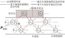
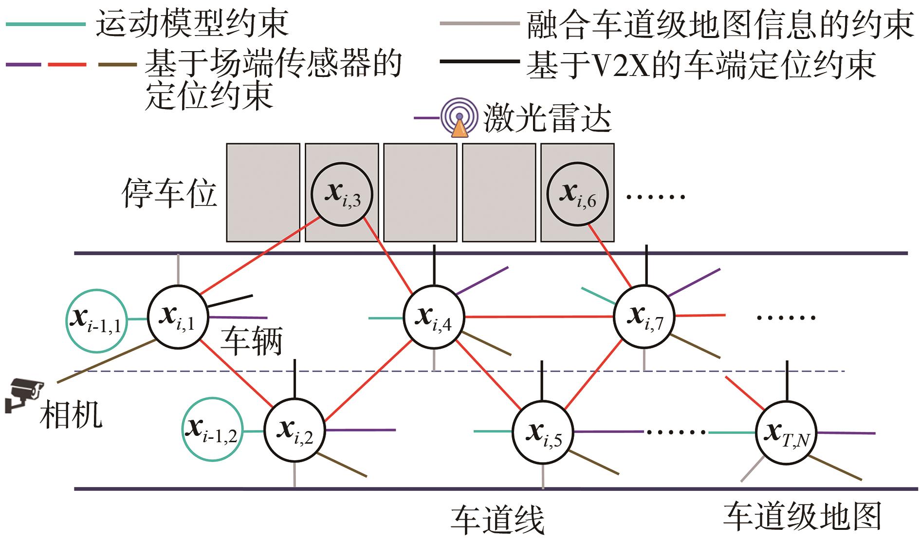
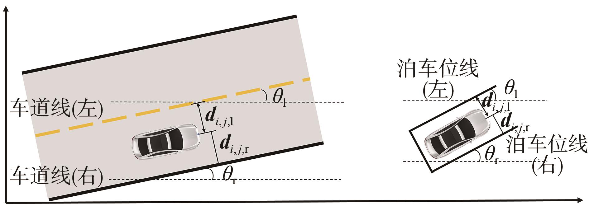
胡钊政,孙勋培,张佳楠,等.基于时空图模型的车-路-图协同定位方法[J/OL].吉林大学学报(工学版),1-12[2024-02-28].
|
|
HU Z Z, SUN X P, ZHANG J N, et al. Vehicle-infrastructure-map cooperative localization method based on spatial-temporal graph model[J/OL]. Journal of Jilin University(Engineering and Technology Edition),1-12[2024-02-28].
|
| 16 |
IBISCH A, STUMPER S, ALTINGER H, et al. Towards autonomous driving in a parking garage: vehicle localization and tracking using environment-embedded LIDAR sensors [C]. 2013 IEEE Intelligent Vehicles Symposium. Gold Coast, QLD: IEEE, 2013: 829-834.
|
| 17 |
ZHANG J, CHEN B,CEN M, et al. Indoor parking method based on cooperation of intelligent vehicle and parking lot[J]. Journal of Physics: Conference Series,2020,1651(1):012004.
|
| 18 |
ZHANG L, XU X B, JIA H, et al. Calibration method of 2D LIDAR and camera based on indoor structural features[J]. ACTA Photonica Sinica, 2020,49(12):61-72.
|
| 19 |
ROMA M. Large-scale unconstrained optimization [M] // PARDALOS P M, PROKOPYEV O A. Encyclopedia of Optimization. Cham: Springer, 2024. DOI: 10.1007/978-3-030-54621-2_324-1.
|
| 20 |
张小俊,奚敬哲,史延雷,等.面向路侧视角目标检测的轻量级YOLOv7-R算法[J].汽车工程,2023,45(10):1833-1844.
|
|
ZHANG X J, XI J Z, SHI Y L, et al. Lightweight YOLOv7-R algorithm for road-side view target detection[J]. Automotive Engineering, 2023,45(10):1833-1844.
|
| 21 |
刘畅,赵津,刘子豪,等.基于欧氏聚类的改进激光雷达障碍物检测方法[J].激光与光电子学进展,2020,57(20):254-260.
|
|
LIU C, ZHAO J, LIU Z H, et al. Improved lidar obstacle detection method based on euclidean clustering[J]. Laser & Optoelectronics Progress, 2020,57(20):254-260.
|
| 22 |
张佳楠,胡钊政,孟杰,等.面向车-路-图协同的分布式自动驾驶仿真平台架构及应用[J].汽车工程,2024,46(8):1335-1345,1356.
|
|
ZHANG J N, HU Z Z, MENG J, et al. Distributed simulation platform architecture of autonomous driving for vehicle-road-map collaboration with its applications[J]. Automotive Engineering, 2024,46(8):1335-1345,1356.
|
 )
)