| [1] |
ZHANG Q, HOU J, HU X, et al. Vehicle parameter identification and road roughness estimation using vehicle responses measured in field tests[J]. Measurement, 2022, 199: 111348.
|
| [2] |
杜昭,张文榕,朱兴一.基于网联车辆数据融合的路面平整度评估方法[J].中国公路学报,2024,37(6):302-316.
|
|
DU Z, ZHANG W R, ZHU X Y. Road roughness assessment based on fusion of connected-vehicles data [J]. China Journal of Highway and Transportation,2024,37(6):302-316.
|
| [3] |
WANG R, LIU W, DING R, et al. Switching control of semi-active suspension based on road profile estimation[J]. Vehicle System Dynamics, 2022, 60(6): 1972-1992.
|
| [4] |
SANG Y, YU Q, FANG Y, et al. Smartphone-based IRI estimation for pavement roughness monitoring: a data-driven approach[J]. IEEE Internet of Things Journal, 2024, 11(11): 19708–19720.
|
| [5] |
梁冠群, 赵通, 王岩, 等. 基于 LSTM 网络的路面不平度辨识方法[J]. 汽车工程, 2021, 43(4): 509-517.
|
|
LIANG G Q, ZHAO T, WANG Y, et al. Road unevenness identification based on LSTM network [J]. Automotive Engineering,2021,43(4):509-517.
|
| [6] |
李韶华,李健玮,冯桂珍.基于GA-LSTM自适应卡尔曼滤波的路面不平度识别[J].振动与冲击,2024,43(9):121-130.
|
|
LI S H, LI J W, FENG G Z. Road roughness recognition based on GA-LSTM adaptive Kalman filtering [J]. Journal of Vibration and Shock, 2024,43(9):121-130.
|
| [7] |
YAN K, ZHANG Z. Automated asphalt highway pavement crack detection based on deformable single shot multi-box detector under a complex environment[J]. IEEE Access, 2021, 9: 150925-150938.
|
| [8] |
HOU Y, SHI H, CHEN N, et al. Vision image monitoring on transportation infrastructures: a lightweight transfer learning approach[J]. IEEE Transactions on Intelligent Transportation Systems, 2022, 24(11): 12888-12899.
|
| [9] |
ZHANG Z, LIU F, HUANG Y, et al. Detection and statistics system of pavement distresses based on street view videos[J]. IEEE Transactions on Intelligent Transportation Systems, 2024, 25(10): 15106-15115.
|
| [10] |
CHENG H, ZHANG B, ZHONG Y, et al. Quantitative pixel-level segmentation and 3D reconstruction of concealed cracks in asphalt pavements[J]. IEEE Transactions on Intelligent Transportation Systems, 2024, 25(11): 18136-18152.
|
| [11] |
王雪玮,李思渊,梁晓,等.基于结构重参数化与自适应注意力的复杂路面快速识别模型[J].中国公路学报,2024,37(3):245-258.
|
|
WANG X W, LI S Y, LIANG X, et al. A fast identification model for complex pavement based on structural reparameterization and adaptive attention [J]. China Journal of Highway and Transportation, 2024,37(3):245-258.
|
| [12] |
王海,李建国,蔡英凤,等.基于激光雷达点云的动态驾驶场景多任务分割网络[J].汽车工程,2024,46(9):1608-1616.
|
|
WANG H, LI J G, CAI Y F, et al. A lidar-based dynamic driving scene multi-task segmentation network [J]. Automotive Engineering, 2024,46(9):1608-1616.
|
| [13] |
XIONG H, ZHU T, LIU Y, et al. Road-model-based road boundary extraction for high definition map via lidar[J]. IEEE Transactions on Intelligent Transportation Systems, 2022, 23(10): 18456-18465.
|
| [14] |
CHEN T H, CHANG T S. RangeSeg: range-aware real time segmentation of 3D LiDAR point clouds[J]. IEEE Transactions on Intelligent Vehicles, 2021, 7(1): 93-101.
|
| [15] |
李思纯,王建军,宋伟润,等.无人驾驶扫地机道路可行驶区域的融合提取研究[J].仪器仪表学报,2024,45(12):190-200.
|
|
LI S C, WANG J J, SONG W R, et al. Fusion extraction of road drivable area for unmanned sweepers [J]. Chinese Journal of Scientific Instrument, 2024,45(12):190-200.
|
| [16] |
马新江,岳东杰,沈月千,等.基于车载激光点云的路面坑槽检测方法[J].中国激光,2024,51(5):190-203.
|
|
MA X J, YUE D J, SHEN Y Q, et al. Pavement pothole detection method based on vehicle-mounted laser point cloud[J]. Chinese Journal of Lasers,2024,51(5):190-203.
|
| [17] |
GUO Y, WANG H, HU Q, et al. Deep learning for 3D point clouds: a survey[J]. IEEE Transactions on Pattern Analysis and Machine Intelligence, 2020, 43(12): 4338-4364.
|
| [18] |
ZHAO T, GUO P, HE J, et al. A hierarchical scheme of road unevenness perception with lidar for autonomous driving comfort[J]. IEEE Transactions on Intelligent Vehicles, 2023, 9(1): 2439-2448.
|
| [19] |
SHAN Y, FU Y, CHEN X, et al. LiDAR based traversable regions identification method for off-road UGV driving[J]. IEEE Transactions on Intelligent Vehicles, 2023, 9(2): 3544-3557.
|
| [20] |
卢才武,薛佳楠,李萌,等.基于露天矿三维点云的非结构化道路语义分割方法[J].煤炭学报,2024,49(S2):1295-1309.
|
|
LU C W, XUE J N, LI M, et al. Unstructured road semantic segmentation method based on 3D point cloud of open pit mine [J]. Journal of China Coal Society, 2024,49(S2):1295-1309.
|
| [21] |
QI C R, YI L, SU H, et al. Pointnet++: deep hierarchical feature learning on point sets in a metric space[J]. Advances in Neural Information Processing Systems, 2017, 30.
|
| [22] |
王章宇,陈阳,周彬,等.一种面向非结构化道路的点云语义分割方法[J].北京航空航天大学学报,2025,51(2):457-465.
|
|
WANG Z, CHEN Y, ZHOU B, et al. A point cloud semantic segmentation method for unstructured roads[J]. Journal of Beijing University of Aeronautics and Astronautics, 2025, 51(2): 457-465.
|
| [23] |
伍文广, 田双岳, 张志勇, 等. 非铺装道路凹凸不平特征语义分割方法研究[J]. 汽车工程, 2023, 45(8): 1468-1478.
|
|
WU W G, TIAN S Y, ZHANG Z Y, et al. Research on semantic segmentation of uneven features of unpaved road [J].Automotive Engineering, 2023, 45(8): 1468-1478.
|
| [24] |
LIN T. Focal loss for dense object detection[J]. arXiv preprint arXiv:, 2017.
|
| [25] |
LIU Z, WANG Y, VAIDYA S, et al. KAN: Kolmogorov-arnold networks[J]. arXiv preprint arXiv:, 2024.
|
| [26] |
ARMENI I, SENER O, ZAMIR A R, et al. 3D semantic parsing of large-scale indoor spaces[C]. Proceedings of the IEEE Conference on Computer Vision and Pattern Recognition, 2016: 1534-1543.
|
| [27] |
DAI A, CHANG A X, SAVVA M, et al. ScanNet: richly-annotated 3D reconstructions of indoor scenes[C]. Proceedings of the IEEE Conference on Computer Vision and Pattern Recognition, 2017: 5828-5839.
|
| [28] |
QI C R, SU H, MO K, et al. PointNet: deep learning on point sets for 3D classification and segmentation[C]. Proceedings of the IEEE Conference on Computer Vision and Pattern Recognition, 2017: 652-660.
|
| [29] |
ZHAO H, JIANG L, JIA J, et al. Point transformer[C]. Proceedings of the IEEE/CVF International Conference on Computer Vision, 2021: 16259-16268.
|
| [30] |
MA X, QIN C, YOU H, et al. Rethinking network design and local geometry in point cloud: a simple residual MLP framework[J]. arXiv preprint arXiv:, 2022.
|
| [31] |
XU M, ZHANG J, ZHOU Z, et al. Learning geometry-disentangled representation for complementary understanding of 3D object point cloud[C]. Proceedings of the AAAI Conference on Artificial Intelligence, 2021, 35(4): 3056-3064.
|
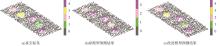
 ),邱松江1,胡林1,张晓强2,邱增华3,汪嘉凯1